One of the applications with the greatest margin of growth on iOS is certainly the one dedicated to map management and navigation. Although it has been presented for many years now, the differences, compared to the more formidable Google Maps adversary, are quite evident. Indeed, basic functions are not lacking, such as public transport, which are available in very few cities around the world.

With iOS 13 the 3D view is also added, commonly known as “Street View”. Unfortunately, even in this case, very few areas are affected, but obviously with time they will increase. So let’s see how to use this feature within Apple Maps.
Start “Street View” on Apple Maps
At the time of writing this article, the 3D view of Apple Maps is available in very few cities, including Los Angeles and Honolulu. Precisely for th
is reason, in the photo below, we will use one of these two areas. Obviously we invite you to periodically check the presence of the function in all the interested roads to keep up to date.
- Open the “Maps ” application on iPhone, iPad and iPod Touch with iOS 13
- Search for an area covered
accutane online in the best USA pharmacy https://mirskin.com/wp-content/uploads/2025/12/wiki/wiki-accutane.html no prescription with fast delivery drugstore
by the function (Honolulu in our case)
- Zoom in on any road until a binocular icon appears on the right
- Click on the binoculars
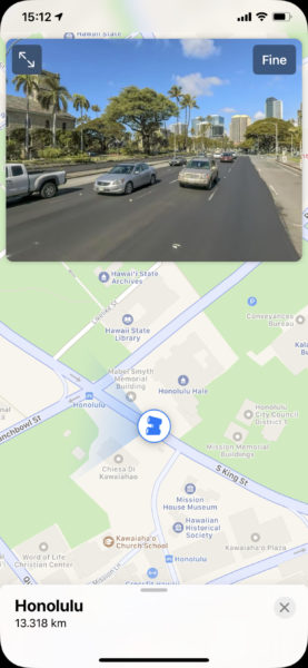
At this point a small window will open at the top with the 3D view of the map. By clicking on the magnification icon at the top left you can completely hide the 2D map, while clicking on “Finish” at the top right, everything will be deactivated.
Doubts or problems? We help you
If you still have any doubt or suggestion related to this article then feel free to leave a comment in the box below or contact us via our dedicated page.